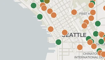
There are five practical ways to track construction projects in the Seattle metro area. They are the cities' own permit portals, local news coverage, walking or driving the neighborhoods, free public maps and open data, and a paid tracker such as BuildVue. The right choice depends on how many places you are watching, how early you need to hear about a project, and how much of your own time you are willing to spend.
This page describes all five and how each one works. If you only need the records at one address today, the shorter answer is in how to look up building permits in Seattle.
The cities' own permit portals
Every project in the region starts as a permit application. The city that issues the permit is the source of record for it. Seattle publishes its records through the Seattle Services Portal. Bellevue and a dozen other King County cities share a portal called MyBuildingPermit. Tacoma runs Accela Citizen Access under the name Tacoma Permits, and Everett runs a system called eTRAKiT. Each city's search is written up separately in the guides for Seattle, Bellevue, Tacoma and Everett.
What it is. The portal shows the city's own file for each permit, including the fee history, the inspection results, the correction notices and the documents the applicant filed. The city record is the official record for a legal or due diligence question.
What it costs. It costs time, and quite a lot of it. Each portal is a different piece of software with a different search form, so what you learn in one city does not apply to the next. The portals search one jurisdiction at a time. Watching the metro area means repeating the same search across a long list of sites. They also return one permit per row rather than one project per row, so a single building shows up as five or six separate records you have to reassemble yourself. Most of them are free to use, and most do not require an account to read records. Everett's portal asked for a login on its search pages when we checked.
Who it suits. This route suits anyone who has a specific address and a specific question, anyone who needs the underlying documents, and anyone who only follows one city.
Local news coverage
Publications such as The Urbanist, the Daily Journal of Commerce, The Seattle Times and The News Tribune cover development in the region. Neighborhood blogs cover a single district in more depth.
What it covers. A news article names the project, the developer and the architect. It describes what was on the site before, reports what neighbors said at the hearing, and often includes the renderings. Reporting also explains why a project is happening and why one has stalled.
What it costs. Some titles are free to read and some ask for a subscription or a membership. The bigger cost is in what gets covered at all. Journalists write about the projects that are large, contested or interesting. That leaves most of the pipeline unwritten. A news article appears once the reporter has finished, not when the permit is filed. The permit record shows the project first.
Who it suits. This route suits anyone who wants to understand a handful of significant projects properly, and anyone who wants the human side of a development rather than its file.
Walking or driving the neighborhood
Washington requires a public notice at every permitted site, and construction is visible from the street.
What you see. A site notice shows the permit number, the type of work and where to comment. A fence and a crane mean the project is real and work has started.
What it costs. The trip costs nothing but your time, and it does not scale. Seeing what is happening across four cities on foot is not something anyone does twice. It is also late by definition. A project only becomes visible from the street once it has cleared review, which can be a year or more after the application went in.
Who it suits. This route suits anyone whose interest is a few blocks wide, and anyone checking that a project that exists on paper has actually started.
Free public maps and open data
Seattle publishes its building permit records as an open dataset on data.seattle.gov, refreshed daily. The dataset can be filtered, mapped and downloaded in the browser, or read through an API. King County publishes a parcel viewer and an online property record search. Both show lot lines, zoning designations, assessed values and sale history. Other counties and several cities publish similar layers.
What it contains. Open data covers every permit in a city, free to download. The parcel layers add ownership and zoning detail.
What it costs. It takes effort and some skill. Open data comes as raw rows with no project grouping, no images and no interpretation. Turning it into an answer means doing the analysis yourself, and using the API takes some technical comfort. Coverage is uneven too. Not every city in the metro area publishes an open dataset, and the ones that do publish them in different shapes.